
Data info
Domain
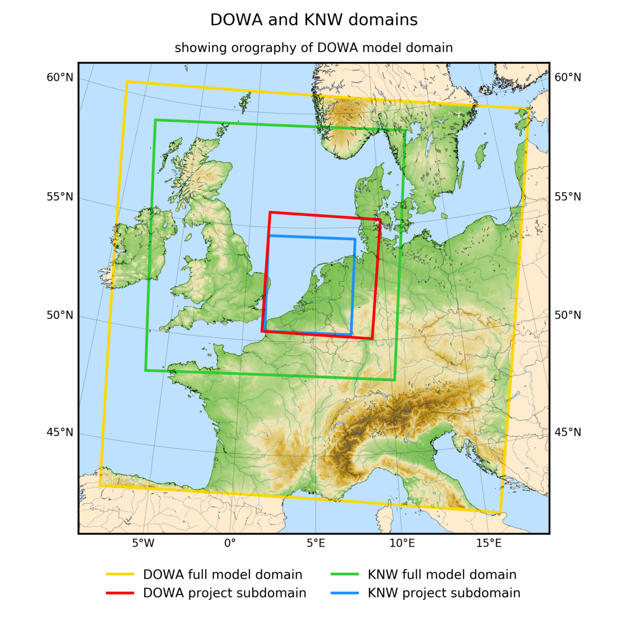
A 10 year ERA5-HARMONIE (Cycle 40h1.2tg2) re-analyses was made and saved on a domain of 789 by 789 points centered around Cabauw (yellow area in figure below). Specifically for the DOWA project a dedicated set of output files was created for a smaller subdomain (red area in the figure below). Both the whole domain and the domain made publicly available are larger in the DOWA than in the KNW-atlas (see figure 1).
Variables
The list of variables saved for the DOWA-subdomain is given under 1 and 2. Where mentioned the 17 height levels refer to: 10, 20, 40, 60, 80, 100, 120, 140, 150, 160, 180, 200, 220, 250, 300, 500 and 600m.
(1) Variables that are made publicly available (Until May 2020) through the KNMI Data Centre and are validated in the DOWA-project (for the red domain for 2008-2017):
- Wind speed at 17 height levels
- Wind direction at 17 height levels
(2) Variables that are made publicly available (Until May 2020) through the KNMI Data Centre, but are not validated in the DOWA-project (for the red domain for 2008-2017):
- Air pressure at 17 height levels
- Air temperature at 17 height levels
- Relative humidity at 17 height levels
(3) Variables that are NOT part of the DOWA-project, but are temporally made publicly available (Until March 2020) through the KNMI Data Centre (for the red domain for 2018):
- Wind speed at 17 height levels
- Wind direction at 17 height levels
- Air pressure at 17 height levels
- Air temperature at 17 height levels
- Relative humidity at 17 height levels
These data are also available as daily files 2018 and time series 2018. If the data is no longer on the KNMI Data Centre, the archived data can be made available, but not free of charge. The data can be used freely as long as KNMI is cited as the source of the information. The data is not validated.
(4) Variables that are NOT part of the DOWA-project, but are temporally made publicly available (Until March 2020) through the KNMI Data Centre (for the yellow domain for 2008-2017):
daily_DOWA_files_all_parameters_full_domain. If the data is no longer on KDC, the archived data can be made available, but not free of charge. The data can be used freely as long as KNMI is cited as the source of the information. The data is not validated. Beware: it is a very large dataset (yellow domain) and downloading the data will take a lot of time!
Variables are either given on single levels (fixed heights e.g. at sea or ground level, 2 m, 10 m or in the soil) or on model levels (in [hPA]) (There are 65 model levels. Model levels are not in “fixed” hPA-levels, but depend on the surface pressure. The higher the model levels, the less dependent on the surface pressure: the highest model level is at 10 hPa.).
Variables at single level:
- Surface roughness length (z0) [m]
- Surface roughness length for heat in air (z0h) [m]
- Air pressure at specified altitude above mean sea level (psl) [Pa]
- Surface air pressure (ps) [Pa]
- Sea surface temperature at mean sea level (sst) [K]
- Surface temperature (ts) [K]
- Atmosphere boundary layer thickness (zmla) [m]
- Accumulated surface downward eastward stress (tauu) [kg m-1 s-1]
- Accumulated surface downward northward stress (tauv) [kg m-1 s-1]
- Cloud area fraction (clt) [0-1]
- Cloud area fraction low-level cloud (below 2500m) in atmosphere layer (cll) [0-1]
- Cloud area fraction medium level cloud (2500-5000m) in atmosphere layer (clm) [0-1]
- Cloud area fraction high-level cloud (above 5000m) in atmosphere layer (clh) [0-1]
- Accumulated surface net shortwave flux in air (rsns) [J m-2]
- Accumulated surface net longwave flux in air (rlns) [J m-2]
- Accumulated top-of-atmosphere net shortwave flux (rsnt) [J m-2]
- Accumulated top-of-atmosphere net longwave flux (rlnt) [J m-2]
- Accumulated surface downwelling longwave flux in air (rlds) [J m-2]
- Accumulated surface downwelling shortwave flux in air (rsds) [J m-2]
- Accumulated surface upward sensible heat flux (hfss) [J m-2]
- Accumulated surface upward latent heat flux evaporation (hfls_eva ) [ J m-2]
- Accumulated surface upward latent heat flux sublimation (hfls_sbl) [J m-2]
- Atmosphere convective inhibition (CIN) as calculated by Harmonie CAPE type 5 (cin_harm) [J kg-1]
- Atmosphere convective inhibition (CIN) conform ECMWF definition (cin_ecmwf) [J kg-1]
- Atmosphere convective available potential energy (CAPE) as calculated by Harmonie CAPE type 5 (cape_harm) [J kg-1]
- Atmosphere convective available potential energy (CAPE) conform ECMWF definition (cape_ecmwf) [J kg-1]
- Rainfall amount in one hour (prrain) [kg m-2]
- Snowfall amount in one hour (prsn) [kg m-2]
- Surface snow amount (snw) [kg m-2]
- Graupel amount in one hour (prgrpl) [kg m-2]
- Air temperature at 2 m height (tas) [K]
- Max air temperature over one hour at 2 m height (tasmax) [K]
- Min air temperature over one hour at 2 m height (tasmin) [K]
- Specific humidity (huss) at 2 m height [-]
- Eastward wind at 10 m height (uas) [m s-1]
- Northward wind at 10 m height (vas) [m s-1]
- Max eastward wind gust (3 sec averaged wind speed) at 10 m height between current and previous hour (ugs) [m s-1]
- Max northward wind gust (3 sec averaged wind speed) at 10 m height between current and previous hour (vgs) [m s-1]
Variables at all HARMONIE model levels:
- Geopotential (phi) [m2 s-2]
- Air temperature (ta) [K]
- Eastward wind (ua) [m s-1]
- Northward wind (va) [m s-1]
- Vertical velocity (vv) [m s-1]
- Specific humidity (hus) [-]
- Cloud area fraction in atmosphere layer (cl) [0-1]
- Mass fraction of cloud ice in air (cli) [-]
- Mass fraction of cloud liquid water in air (clw) [0-1]
Soil variables:
- Soil temperature: top soil layer per patch (tg_LO1.PON)
- Soil temperature: deep soil layer per patch (tg_LO2.PON)
- Volume fraction of liquid water in soil layer: top soil layer per patch (wsa_L01.P0N) [-]= m3 liquid water/ m3 soil. Note: HARMONIE distinguishes between 2 patches: “open land” and “forest”. Soil parameters for these patches are stored separately.
- Volume fraction of liquid water in soil layer: root layer per patch (wsa_L02.P0N) [-]
- Volume fraction of liquid water in soil layer: deep soil layer per patch (wsa_L03.P0N) [-]
- Volume fraction of frozen water in soil: top soil layer per patch (isa_L01.P0N) [-][3] = m3 ice/ m3 soil
- Volume fraction of frozen water in soil: deep soil per patch (isa_L02.P0N) [-]
More info on HARMONIE-40h1 parameters (accessible for KNMI staff).
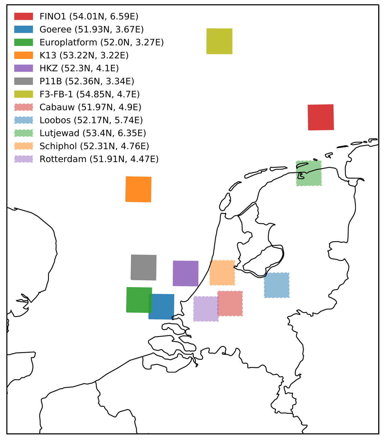
For 2016 and 2017 and 12 locations (see figure 2) there are additional variables (vertical profiles and large-scale dynamic tendencies of the wind components, temperature and specific humidity) made available to enable LES downscaling of HARMONIE using the “large scale or dynamic tendency method”. The information is stored as a single column and 10x10 km and 30x30km averages.
Future data
KNMI has transfered all data from the KNMI Data Centre to the cloud in July 2020, including the Dutch Offshore Wind Atlas (DOWA) and KNMI North Sea Wind atlas (KNW) data. Although KNMI will try to keep the consequences of this change to a minimum, you might encounter problems. If you do, please contact dataservices@knmi.nl.
A new project has started (WINS50) in which KNMI will produce more DOWA years (2019-2021). KNMI expects to make the 2019 DOWA data available in 2021.